Stretch of heat rolls on through midweek for the Hudson Valley
It will be a mild night with a chance for late-day showers.
More Stories


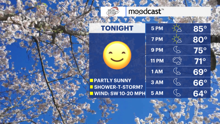
Tonight will feel more like summer than spring, with lows in the 60s under partly cloudy skies. We remain locked in a warm pattern, as a steady southerly flow continues to bring in unseasonably warm air. There is also a good chance for a few passing showers later this evening.
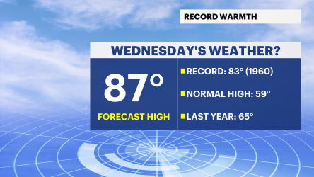
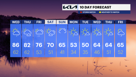
Wednesday will be the hottest day of the week—and potentially a record-breaker. The current record high for this date is 83 degrees, set in 1960. Forecasted highs are expected to soar into the upper 80s, making it feel more like June. A pop-up shower or even a gusty storm is possible late in the day.
Thursday stays warm, with highs once again in the 80s and another chance for an afternoon shower.
Looking ahead, a weather system is expected to impact the region on Friday, bringing more scattered showers. Another cold front arrives on Sunday, leading to more widespread rain and ushering in a noticeable cooldown.
By Monday, temperatures return to more seasonable levels.
TONIGHT: Low 60s. Partly cloudy with the chance of a shower.
TOMORROW: Mostly sunny. Upper 80s. Chance for afternoon shower/storm.
ALMANAC (April 15)
Record High: 83 (1960)
Record Low: 29 (1973)
Sunrise: 6:15 a.m.
Sunset: 7:34 p.m.